
 |
|  |
|


Function
Ideal position sensors for radar, AIS, ECDIS, autopilot, bathymeter and other navigation and communication equipment
Fully meet the performance test standards of IMO MSC. 112 (73) and IEC 61108-1: GPS receivers
High sensitivity antenna elements enhance the stability and accuracy of positioning.
GPS receiver integrates stronger noise suppression function, realizes anti-jamming function and requires antenna unit GPA-020S or GPA-021S for advanced tolerance to multi-path suppression.
Improving and enhancing accuracy by using SBAS (Satellite Enhancement System) and DGPS (Required optional GPS radio beacon receiver and antenna unit GPA-021S)
Fully meet the performance test standards of IMO MSC. 114 (73) and IEC 61108-4: DGPS radio beacon receivers
10 Hz position update rate (position update every 0.1 seconds) to achieve stable ship position tracking
Front panel with USB interface
Route data, menu settings, user settings can be input and output through USB flash memory.
Route data, menu settings, user settings can be input and output through USB flash memory
Route points, routes and other data set by users on one device can be shared with another device for backup.
Preparations for BAM (Bridge Building Alarm Management)
It meets the standard requirements of IMO MSC. 302 (87) alarm and internal interconnection.
The network interface fully meets the new mandatory Ethernet communication standard IEC61162-450, and can effectively access the efficient network integration bridge building system.
GP-170 Fully Compatible Light Network (IEC61162-450)
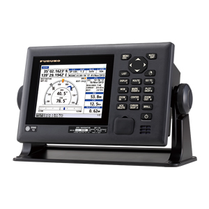
5.7 inch color LCD (640x480 pixels) display data
Simple Operational Menu
Operators can navigate through the menu tree and enter the menu by clicking on the number of corresponding menu items on the cursor disk or on the digital keyboard.
Enhancing Route Planning and Management Functions
The whole range of navigation information will be integrated into the route.
Create streamlined routes with external computers
The route information can be transmitted to the electronic chart to supplement the ability of route monitoring.
Specifications
Display unit
| Type | 5.7 "color liquid crystal display (116.16 mm x 87.12 mm) |
| Screen resolution | 640 (H) x 480 (V) pixels (VGA) |
| GPS antenna | GPA-017S/GPA-020S/GPA-0215* (Designation at scheduled time) * Optional when beacon receiver is loaded into display unit. |
| Display mode | Plotter, route, course, data, synthesis |
GPS / SBAS (WAAS/EGNOS/MSAS)
| Receiving type | GPS: 12 ch SBAS: 2 ch |
| Receiving frequency | 1575.42 MHz±1.023 MHz |
| Positioning accuracy | GPS: No more than 10 m DGPS: No more than 5 m WAAS: No more than 3 m MSAS: No more than 7 m |
Graph plotter
| Memory capacity | 1,000 comment points, up to 20 per point Characters; 2,000 Route points; 100 routes (1,000 routes per route) |
Other
| Waterproof grade | Display unit: IP25 Antenna unit: IP56 |
| Power | 12-24 VDC |
| Size | 185 (H) x 275 (W) x 89 (D) |
| Weight | 2.2 kg 4.9 lb (GPS-free beacon receiver) 2.4 kg 5.29 lb (Beacon Receiver Including DGPS) |

WeChat Official Account